
Pinet topographic map
Interactive map
Click on the map to display elevation.
About this map
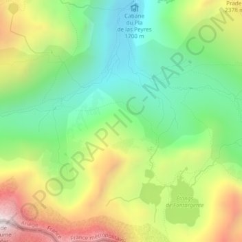
Name: Pinet topographic map, elevation, terrain.
Average elevation: 2,093 m
Minimum elevation: 1,697 m
Maximum elevation: 2,697 m
Other topographic maps
Click on a map to view its topography, its elevation and its terrain.
Pas de la Soulane
France > Occitanie > Ariège > Aston
Pas de la Soulane, Aston, Foix, Ariège, Occitanie, France métropolitaine, 09310, France
Average elevation: 2,320 m
Étang de Soulanet
France > Occitanie > Ariège > Aston
Étang de Soulanet, Aston, Foix, Ariège, Occitanie, France métropolitaine, 09310, France
Average elevation: 2,418 m