
Make a donation
Cali topographic map
Click on the map to display elevation.
Make a donation
Cali
Under Köppen's climate classification, Cali features a dry-summer tropical savanna climate (Köppen climate classification: As), closely bordering a tropical monsoon climate (Köppen: Am). The Western Mountain Range rises from an average of 2,000 m (6,562 ft) above sea level in the northern part of the city to approximately 4,000 m (13,123 ft) to the south. Because of this variation in altitude, the weather in the northwest portion of the city is drier than in the southwest. The average annual precipitation varies between 900 and 1,800 mm (35 and 71 in) depending on the metropolitan zone for a citywide average of approximately 1,483 mm (58 in). Even though there is enough rainfall to make for lush surroundings, Cali is still in a strong rain shadow. Its closest seaport of Buenaventura about 80 kilometres (50 mi) away is among the rainiest locations in the world. This is due to Buenaventura being on the windward side of the coastal mountains that in return shield Cali from the Pacific monsoons. Cali's average temperature is 24 °C (75 °F) with an average low temperature of 17.4 °C (63 °F) and a high of 30.5 °C (87 °F).
Make a donation
About this map
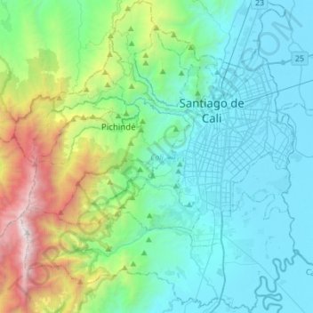
Name: Cali topographic map, elevation, terrain.
Location: Cali, Sur, Valle del Cauca, RAP Pacífico, Colombia (3.27341 -76.70694 3.54858 -76.45890)
Average elevation: 1,286 m
Minimum elevation: 940 m
Maximum elevation: 3,084 m
Make a donation
Other topographic maps
Click on a map to view its topography, its elevation and its terrain.
Make a donation
Make a donation
Make a donation