
Central Region topographic map
Interactive map
Click on the map to display elevation.
About this map
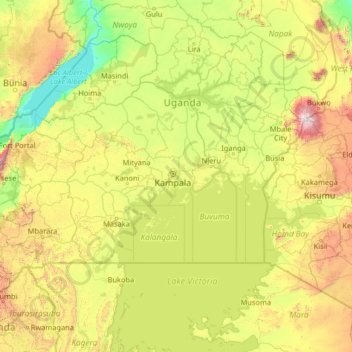
Name: Central Region topographic map, elevation, terrain.
Location: Central Region, Uganda (-2.27846 30.06708 2.84154 35.18708)
Average elevation: 1,230 m
Minimum elevation: 612 m
Maximum elevation: 4,261 m
Other topographic maps
Click on a map to view its topography, its elevation and its terrain.
City Square
Uganda > Central Region > Kampala > Central
City Square, Kikuubo, Central, Kampala, Central Region, Uganda
Average elevation: 1,181 m
Isreal-matovu
Uganda > Central Region > Kampala
Isreal-matovu, Kampala, Central Region, Uganda
Average elevation: 1,187 m