
Thank you for supporting this site ❤️
Make a donation
Make a donation
Saint-Tite topographic map
Click on the map to display elevation.
Thank you for supporting this site ❤️
Make a donation
Make a donation
About this map
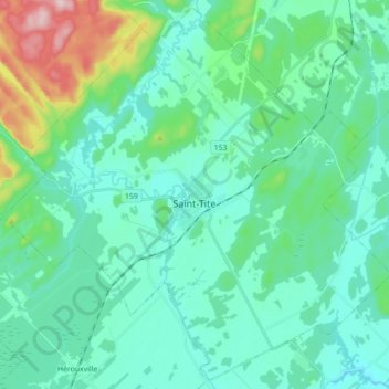
Name: Saint-Tite topographic map, elevation, terrain.
Location: Saint-Tite, Mékinac, Mauricie, Quebec, Canada (46.67338 -72.65114 46.78928 -72.47532)
Average elevation: 174 m
Minimum elevation: 110 m
Maximum elevation: 456 m
Thank you for supporting this site ❤️
Make a donation
Make a donation
Other topographic maps
Click on a map to view its topography, its elevation and its terrain.
Thank you for supporting this site ❤️
Make a donation
Make a donation
Thank you for supporting this site ❤️
Make a donation
Make a donation