
Lanzerath topographic map
Interactive map
Click on the map to display elevation.
About this map
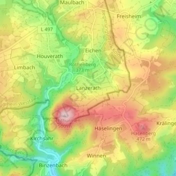
Name: Lanzerath topographic map, elevation, terrain.
Average elevation: 371 m
Minimum elevation: 258 m
Maximum elevation: 491 m
Other topographic maps
Click on a map to view its topography, its elevation and its terrain.
Eschweiler
Deutschland > Nordrhein-Westfalen > Kreis Euskirchen > Bad Münstereifel > Eschweiler
Eschweiler, Bad Münstereifel, Kreis Euskirchen, Nordrhein-Westfalen, Deutschland
Average elevation: 335 m