
Make a donation
Arecibo topographic map
Click on the map to display elevation.
Make a donation
About this map
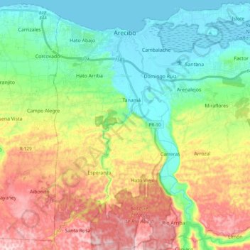
Name: Arecibo topographic map, elevation, terrain.
Location: Arecibo, Puerto Rico, United States (18.31523 -66.77073 18.49432 -66.57980)
Average elevation: 152 m
Minimum elevation: -1 m
Maximum elevation: 417 m
Make a donation
Other topographic maps
Click on a map to view its topography, its elevation and its terrain.
Dorado
United States > Puerto Rico > Dorado > Dorado
Dorado is located in Puerto Rico's Northern Karst region. Much of its geology consists of alluvial and coastal/estuarine sediments of Quaternary age and limestones of Tertiary age. The limestones are mostly in the south part of the municipality, in Espinosa, Maguayo and Rio Lajas barrios. These limestones…
Average elevation: 7 m
Culebra
United States > Puerto Rico > Culebra > Culebra
Culebra is characterized by an irregular topography resulting in a long intricate shoreline. The island is approximately 7 by 5 miles (11 by 8 km). The coast is marked by cliffs, sandy coral beaches and mangrove forests. Inland, the tallest point on the island is Mount Resaca, with an elevation of 636 ft…
Average elevation: 16 m
Make a donation