
Make a donation
Mammoth Lakes topographic map
Click on the map to display elevation.
Make a donation
Mammoth Lakes
Mammoth Lakes is a town in Mono County, California, and is the county's only incorporated community. It is located immediately to the east of Mammoth Mountain, at an elevation of 7,880 feet (2,400 m). As of the 2020 United States Census, the population was 7,191, reflecting a 12.7% decrease from the 2010 Census.
Make a donation
About this map
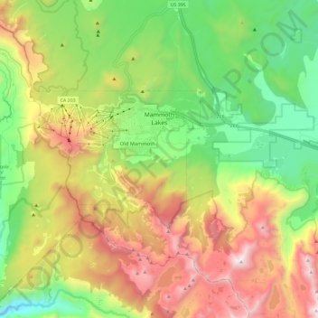
Name: Mammoth Lakes topographic map, elevation, terrain.
Average elevation: 2,682 m
Minimum elevation: 1,914 m
Maximum elevation: 3,822 m
Make a donation
Other topographic maps
Click on a map to view its topography, its elevation and its terrain.
Bodie
United States > California > Mono County
Bodie (/ˈboʊdiː/ BOH-dee) is a ghost town in the Bodie Hills east of the Sierra Nevada mountain range in Mono County, California, United States. It is about 75 miles (121 km) southeast of Lake Tahoe, and 12 mi (19 km) east-southeast of Bridgeport, at an elevation of 8,379 feet (2554 m). Bodie became a boom…
Average elevation: 2,627 m