
South-East topographic map
Interactive map
Click on the map to display elevation.
About this map
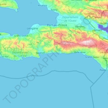
Name: South-East topographic map, elevation, terrain.
Location: South-East, Haiti (18.03150 -73.01559 18.40560 -71.72493)
Average elevation: 234 m
Minimum elevation: -43 m
Maximum elevation: 2,627 m
Other topographic maps
Click on a map to view its topography, its elevation and its terrain.
Kaptaj DINEPA
Haiti > Artibonite Department > Commune de Saint-Marc > Jeanton
Average elevation: 248 m
Port-au-Prince
Haiti > West > Port-au-Prince
By then, the colonial administration was convinced that a capital needed to be chosen, in order to better control the French portion of Hispaniola (Saint-Domingue). For a time, Petit-Goâve and Léogâne vied for this honor, but both were eventually ruled out for various reasons. Neither was centrally located.…
Average elevation: 376 m
Bombardopolis
Haiti > Nord-Ouest Department > Commune Bombardopolis > Bombardopolis
Average elevation: 468 m