
Famagusta topographic map
Click on the map to display elevation.
About this map
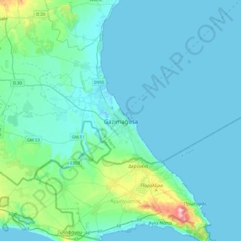
Name: Famagusta topographic map, elevation, terrain.
Location: Famagusta, Northern Cyprus, 99540, Cyprus (34.96454 33.77254 35.28454 34.09254)
Average elevation: 19 m
Minimum elevation: -1 m
Maximum elevation: 175 m
Other topographic maps
Click on a map to view its topography, its elevation and its terrain.
Kyrenia
Another topographical source is the 'Stadiasmus Maris Magni' (from the name 'stadion', a unit measuring distances, 1 stadion = 184 metres). The unknown author, who sailed from Cape Anamur on the Cilician coast to Cyprus and circumnavigated the island, gave the distances from Asia Minor to the nearest point in…
Average elevation: 89 m