
Thank you for supporting this site ❤️
Make a donation
Make a donation
Schelde topographic map
Click on the map to display elevation.
Thank you for supporting this site ❤️
Make a donation
Make a donation
About this map
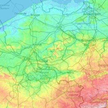
Name: Schelde topographic map, elevation, terrain.
Location: Schelde, Flandern, Belgien (49.98686 3.17524 51.39652 4.39910)
Average elevation: 66 m
Minimum elevation: -4 m
Maximum elevation: 387 m
Thank you for supporting this site ❤️
Make a donation
Make a donation