
Big Bear Lake topographic map
Interactive map
Click on the map to display elevation.
About this map
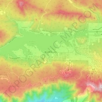
Name: Big Bear Lake topographic map, elevation, terrain.
Average elevation: 2,189 m
Minimum elevation: 1,704 m
Maximum elevation: 2,678 m
Other topographic maps
Click on a map to view its topography, its elevation and its terrain.
Big Bear Lake
Vereinigte Staaten von Amerika > Kalifornien > Big Bear Lake
Big Bear Lake, Lagunita Lane, Big Bear Lake, San Bernardino County, Kalifornien, 92333, Vereinigte Staaten von Amerika
Average elevation: 2,209 m