
Torrance County topographic map
Interactive map
Click on the map to display elevation.
About this map
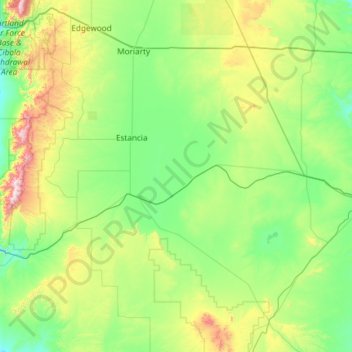
Name: Torrance County topographic map, elevation, terrain.
Location: Torrance County, New Mexico, United States of America (34.25968 -106.47122 35.04214 -105.29014)
Average elevation: 1,983 m
Minimum elevation: 1,725 m
Maximum elevation: 3,035 m
According to the U.S. Census Bureau, the county has a total area of 3,346 square miles (8,670 km2), of which 3,345 square miles (8,660 km2) is land and 0.9 square miles (2.3 km2) (0.03%) is water. Most of the county is gently-rolling grassland ranging from 6000 to 6200 feet in elevation. The Manzano Mountains rising to 10,098 feet on the western edge of the county provide it with its only significant topographic relief. The Manzano Wilderness area includes the highest part of the mountains. The other notable geographic feature of the county is the series of playas and seasonal lakes centering on Laguna del Perro southeast of Estancia.
Other topographic maps
Click on a map to view its topography, its elevation and its terrain.
Acoma Pueblo
United States of America > New Mexico > Acoma Pueblo
Acoma Pueblo, Cibola County, New Mexico, United States of America
Average elevation: 1,929 m
Lincoln County
United States of America > New Mexico
Lincoln County, New Mexico, United States of America
Average elevation: 1,761 m
Santa Fe
United States of America > New Mexico > Santa Fe
Santa Fe, Santa Fe County, New Mexico, United States of America
Average elevation: 2,222 m
Mora County
United States of America > New Mexico
Mora County, New Mexico, United States of America
Average elevation: 2,150 m
Hobbs
United States of America > New Mexico > Hobbs
Hobbs, Lea County, New Mexico, United States of America
Average elevation: 1,108 m