
Make a donation
Cashel topographic map
Click on the map to display elevation.
Make a donation
Cashel
The Rock of Cashel, to which the town below owes its origin, is an isolated elevation of stratified limestone, rising abruptly from a broad and fertile plain called the Golden Vale. The top of this eminence is crowned by a group of remarkable ruins. Originally known as Fairy Hill, or Sid-Druim, the Rock was, in pagan times, the dun, or castle, of the ancient Eoghnacht Chiefs of Munster. In Gaelic, Caiseal denotes a circular stone fort and is the name of several places in Ireland. The "Book of Rights" suggests the name is derived from Cais-il, i.e. "tribute stone", because the Munster tribes paid tribute on the Rock. Here Corc, grandfather of Aengus Mac Natfraich, erected a fort. Cashel subsequently became the capital of Munster and, like Tara and Armagh, it was a celebrated court. At the time of St. Patrick, when Aengus ruled as king, Cashel claimed supremacy over all the royal duns of the province.
Make a donation
About this map
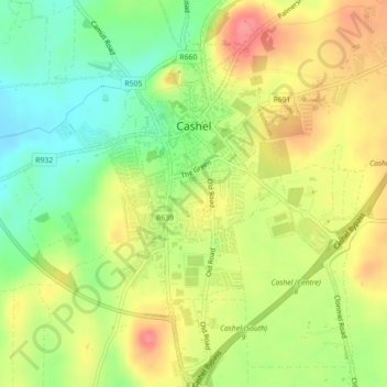
Name: Cashel topographic map, elevation, terrain.
Average elevation: 115 m
Minimum elevation: 77 m
Maximum elevation: 154 m
Make a donation
Other topographic maps
Click on a map to view its topography, its elevation and its terrain.
Make a donation
Make a donation
Make a donation
Make a donation
Make a donation
Make a donation