
Pristina topographic map
Interactive map
Click on the map to display elevation.
About this map
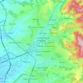
Name: Pristina topographic map, elevation, terrain.
Average elevation: 650 m
Minimum elevation: 548 m
Maximum elevation: 947 m
By the early Iron Age, the distinctly Dardanian local variant of the Illyrian Glasinac-Mati culture appears in Kosovo with a particular spread in hilltop settlements. In the area of Pristina, a hilltop settlement appears since the 8th century BCE at an altitude of 685m near the village Teneshdoll, ~16 km to the north of the Pristina city center. Pottery finds suggests that the area may have been in use since the Bronze Age. The settlement seems to have maintained long-distance trade contacts as the finding of a skyphos vessel from Aegean Greece suggests.
Other topographic maps
Click on a map to view its topography, its elevation and its terrain.
Pristina
Kosovo > Municipality of Pristina > Pristina
Pristina, Municipality of Pristina, 10000, Kosovo
Average elevation: 695 m
Dobërdelan
Dobërdelan, Municipality of Suharekë / Suva Reka, 23060, Kosovo
Average elevation: 591 m