
Thank you for supporting this site ❤️
Make a donation
Make a donation
Cross Anchor topographic map
Click on the map to display elevation.
Thank you for supporting this site ❤️
Make a donation
Make a donation
About this map
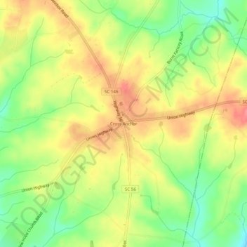
Name: Cross Anchor topographic map, elevation, terrain.
Average elevation: 185 m
Minimum elevation: 144 m
Maximum elevation: 222 m
Thank you for supporting this site ❤️
Make a donation
Make a donation
Other topographic maps
Click on a map to view its topography, its elevation and its terrain.
Lyman Lake
United States > South Carolina > Spartanburg County > Cove Subdivision
Average elevation: 278 m
Thank you for supporting this site ❤️
Make a donation
Make a donation