
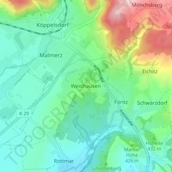
Weidhausen topographic map
Interactive map
Click on the map to display elevation.
About this map
Name: Weidhausen topographic map, elevation, terrain.
Average elevation: 413 m
Minimum elevation: 343 m
Maximum elevation: 607 m
Other topographic maps
Click on a map to view its topography, its elevation and its terrain.
Neuenbau
Deutschland > Thüringen > Landkreis Sonneberg > Föritztal
Neuenbau, Föritztal, Landkreis Sonneberg, Thüringen, 96355, Deutschland
Average elevation: 644 m
Judenbach
Deutschland > Thüringen > Landkreis Sonneberg > Föritztal
Judenbach, Föritztal, Landkreis Sonneberg, Thüringen, Deutschland
Average elevation: 556 m
Jagdshof
Deutschland > Thüringen > Landkreis Sonneberg > Föritztal
Jagdshof, Föritztal, Landkreis Sonneberg, Thüringen, 96524, Deutschland
Average elevation: 548 m