
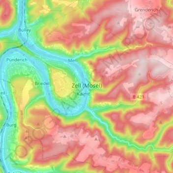
Zell (Mosel) topographic map
Interactive map
Click on the map to display elevation.
About this map
Name: Zell (Mosel) topographic map, elevation, terrain.
Average elevation: 287 m
Minimum elevation: 89 m
Maximum elevation: 458 m
Other topographic maps
Click on a map to view its topography, its elevation and its terrain.
Beilstein
Duitsland > Rijnland-Palts > Landkreis Cochem-Zell
Beilstein, Cochem, Landkreis Cochem-Zell, Rijnland-Palts, Duitsland
Average elevation: 234 m
Roes
Duitsland > Rijnland-Palts > Landkreis Cochem-Zell
Roes, Kaisersesch, Landkreis Cochem-Zell, Rijnland-Palts, Duitsland
Average elevation: 313 m
Neef
Duitsland > Rijnland-Palts > Landkreis Cochem-Zell
Neef, Zell (Mosel), Landkreis Cochem-Zell, Rijnland-Palts, Duitsland
Average elevation: 213 m
Lutzerath
Duitsland > Rijnland-Palts > Landkreis Cochem-Zell
Lutzerath, Ulmen, Landkreis Cochem-Zell, Rijnland-Palts, 56826, Duitsland
Average elevation: 384 m
Cochem
Duitsland > Rijnland-Palts > Landkreis Cochem-Zell
Cochem, Landkreis Cochem-Zell, Rijnland-Palts, Duitsland
Average elevation: 286 m
Bad Bertrich
Duitsland > Rijnland-Palts > Landkreis Cochem-Zell
Bad Bertrich, Ulmen, Landkreis Cochem-Zell, Rijnland-Palts, 56864, Duitsland
Average elevation: 329 m
Brauheck
Duitsland > Rijnland-Palts > Landkreis Cochem-Zell > Cochem
Brauheck, Cochem, Landkreis Cochem-Zell, Rijnland-Palts, Duitsland
Average elevation: 346 m
Gevenich
Duitsland > Rijnland-Palts > Landkreis Cochem-Zell > Gevenich
Gevenich, Ulmen, Landkreis Cochem-Zell, Rijnland-Palts, Duitsland
Average elevation: 404 m
Ediger-Eller
Duitsland > Rijnland-Palts > Landkreis Cochem-Zell
Ediger-Eller, Cochem, Landkreis Cochem-Zell, Rijnland-Palts, Duitsland
Average elevation: 256 m