
Thank you for supporting this site ❤️
Make a donation
Make a donation
Mount Baldy topographic map
Click on the map to display elevation.
Thank you for supporting this site ❤️
Make a donation
Make a donation
About this map
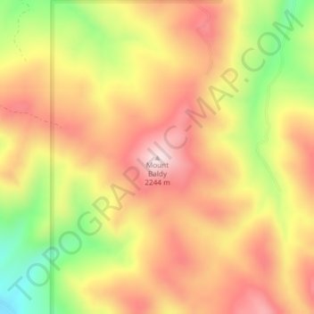
Name: Mount Baldy topographic map, elevation, terrain.
Location: Mount Baldy, Bonneville County, Idaho, United States (43.43903 -111.57445 43.43913 -111.57435)
Average elevation: 2,089 m
Minimum elevation: 1,872 m
Maximum elevation: 2,243 m
Thank you for supporting this site ❤️
Make a donation
Make a donation
Other topographic maps
Click on a map to view its topography, its elevation and its terrain.
Thank you for supporting this site ❤️
Make a donation
Make a donation
Thank you for supporting this site ❤️
Make a donation
Make a donation