
Isla Prat topographic map
Interactive map
Click on the map to display elevation.
About this map
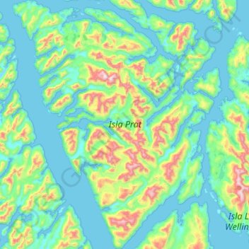
Name: Isla Prat topographic map, elevation, terrain.
Average elevation: 203 m
Minimum elevation: -2 m
Maximum elevation: 1,151 m
Other topographic maps
Click on a map to view its topography, its elevation and its terrain.
Isla Little Wellington
Chile > Región Aysén del General Carlos Ibáñez del Campo > Tortel
Isla Little Wellington, Tortel, Provincia de Capitán Prat, Región Aysén del General Carlos Ibáñez del Campo, Chile
Average elevation: 209 m
Isla Patricio Lynch
Chile > Región Aysén del General Carlos Ibáñez del Campo > Tortel
Isla Patricio Lynch, Tortel, Provincia de Capitán Prat, Región Aysén del General Carlos Ibáñez del Campo, Chile
Average elevation: 105 m
Isla Campana
Chile > Región Aysén del General Carlos Ibáñez del Campo > Tortel
Isla Campana, Tortel, Provincia de Capitán Prat, Región Aysén del General Carlos Ibáñez del Campo, Chile
Average elevation: 155 m