
Dharmajipet topographic map
Interactive map
Click on the map to display elevation.
About this map
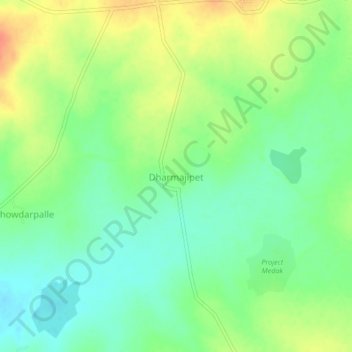
Name: Dharmajipet topographic map, elevation, terrain.
Location: Dharmajipet, Dubbak mandal, Siddipet, Telangana, 502108, India (18.13405 78.61941 18.17405 78.65941)
Average elevation: 493 m
Minimum elevation: 473 m
Maximum elevation: 519 m
Other topographic maps
Click on a map to view its topography, its elevation and its terrain.
Dharmajipet
India > Telangana > Dharmajipet
Dharmajipet, Raikal mandal, Jagtial, Telangana, India
Average elevation: 249 m