
Puig de Galdent topographic map
Interactive map
Click on the map to display elevation.
About this map
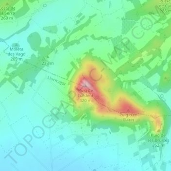
Name: Puig de Galdent topographic map, elevation, terrain.
Average elevation: 225 m
Minimum elevation: 167 m
Maximum elevation: 401 m
Other topographic maps
Click on a map to view its topography, its elevation and its terrain.
Puig de Randa
Spanien > Balearische Inseln > Pla de Mallorca > Algaida
Puig de Randa, Algaida, Pla de Mallorca, Balearische Inseln, 07210, Spanien
Average elevation: 310 m