
Sixteen Mile Creek topographic map
Interactive map
Click on the map to display elevation.
About this map
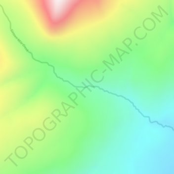
Name: Sixteen Mile Creek topographic map, elevation, terrain.
Average elevation: 1,267 m
Minimum elevation: 1,027 m
Maximum elevation: 1,711 m
Other topographic maps
Click on a map to view its topography, its elevation and its terrain.
Beaver Lake
Canada > British Columbia > Regional District of Kitimat-Stikine > Area F (Dease Lake) > Dease Lake
Beaver Lake, Dease Lake, Area F (Dease Lake), Regional District of Kitimat-Stikine, British Columbia, Canada
Average elevation: 865 m
Dease Lake
Canada > British Columbia > Regional District of Kitimat-Stikine > Area F (Dease Lake)
Dease Lake, Area F (Dease Lake), Regional District of Kitimat-Stikine, British Columbia, V0C 1L0, Canada
Average elevation: 898 m
Ball Creek
Canada > British Columbia > Regional District of Kitimat-Stikine > Area F (Dease Lake)
Ball Creek, Area F (Dease Lake), Regional District of Kitimat-Stikine, British Columbia, Canada
Average elevation: 1,267 m