
灵石县 topographic map
Interactive map
Click on the map to display elevation.
About this map
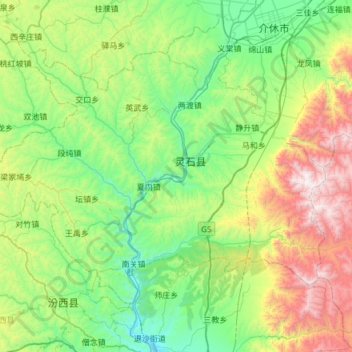
Name: 灵石县 topographic map, elevation, terrain.
Location: 灵石县, 晋中市, 山西省, 中国 (36.65149 111.40028 37.00200 112.00363)
Average elevation: 1,090 m
Minimum elevation: 548 m
Maximum elevation: 2,546 m
Other topographic maps
Click on a map to view its topography, its elevation and its terrain.