
Rodadero topographic map
Interactive map
Click on the map to display elevation.
About this map
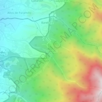
Name: Rodadero topographic map, elevation, terrain.
Average elevation: 1,405 m
Minimum elevation: 1,004 m
Maximum elevation: 2,203 m
Other topographic maps
Click on a map to view its topography, its elevation and its terrain.
San Cristóbal
Venezuela > Estado Táchira > Municipio San Cristóbal
San Cristóbal, Parroquia Pedro María Morantes, Municipio San Cristóbal, Estado Táchira, 5001, Venezuela
Average elevation: 1,220 m
La Blanca
Venezuela > Estado Táchira > Municipio San Cristóbal
La Blanca, Parroquia La Concordia, Municipio San Cristóbal, Estado Táchira, Venezuela
Average elevation: 1,090 m