Dufftown topographic map
Interactive map
Click on the map to display elevation.
About this map
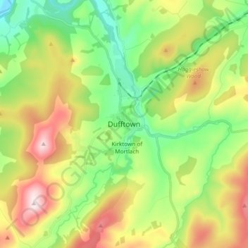
Name: Dufftown topographic map, elevation, terrain.
Location: Dufftown, Moray, Scotland, AB55 4AD, United Kingdom (57.40490 -3.16835 57.48490 -3.08835)
Average elevation: 268 m
Minimum elevation: 79 m
Maximum elevation: 567 m
Other topographic maps
Click on a map to view its topography, its elevation and its terrain.
Glenlivet
United Kingdom > Scotland > Moray
Glenlivet, Moray, Scotland, AB37 9BT, United Kingdom
Average elevation: 280 m
Spey Bay
United Kingdom > Scotland > Moray
Spey Bay, Moray, Scotland, IV32 7RR, United Kingdom
Average elevation: 5 m
Longmorn
United Kingdom > Scotland > Moray > Longmorn
Longmorn, Moray, Scotland, IV30 8SA, United Kingdom
Average elevation: 67 m
Dallas
United Kingdom > Scotland > Moray
Dallas, Moray, Scotland, IV36 2SA, United Kingdom
Average elevation: 205 m
Ballindalloch
United Kingdom > Scotland > Moray > Ballindalloch
Ballindalloch, Moray, Scotland, AB37 9YF, United Kingdom
Average elevation: 233 m
Forres
United Kingdom > Scotland > Moray > Forres
Forres, Moray, Scotland, IV36 1NX, United Kingdom
Average elevation: 31 m
Kinloss
United Kingdom > Scotland > Moray
Kinloss, Moray, Scotland, IV36 3UT, United Kingdom
Average elevation: 10 m