
Make a donation
Latakia Governorate topographic map
Click on the map to display elevation.
Make a donation
Latakia Governorate
The Latakia Governorate comprises about half of Syria's Mediterranean coastline. The western part of the governorate consists mainly of coastal plains, with the inland eastern parts being mountainous, with the Syrian Coastal Mountain Range (Nusayriyah Mountains) running north to south. Its highest peak, Nabi Yunis, is 1,562 meters (5,125 ft) tall with the average elevation only about 1,200 meters. The western areas of the governorate catch moisture-laden winds from the Mediterranean Sea and are thus more fertile and more heavily populated than the eastern slopes.
Make a donation
About this map
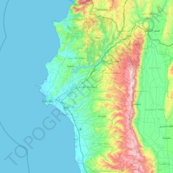
Name: Latakia Governorate topographic map, elevation, terrain.
Location: Latakia Governorate, Syria (35.21667 35.71657 35.94057 36.25519)
Average elevation: 258 m
Minimum elevation: 0 m
Maximum elevation: 1,539 m
Make a donation
Other topographic maps
Click on a map to view its topography, its elevation and its terrain.
Make a donation
A`zaz
During the Crusader era, Azaz, which was referred to in Crusader sources as "Hazart", became of particular strategic significance due to its topography and location, overlooking the surrounding region. In the hands of the Muslims, Azaz stymied communications between the Crusader states of Edessa and Antioch,…
Average elevation: 559 m
Make a donation
Make a donation
Make a donation
Al-Zabadani
Syria > Rif Dimashq Governorate > Al-Zabadani
Al-Zabadani or Az-Zabadani (Arabic: الزبداني, romanized: az-Zabadānī) is a city and popular hill station in southwestern Syria in the Rif Dimashq Governorate, close to the border with Lebanon. It is located in the center of a green valley surrounded by high mountains at an elevation of around 1,100 m.
Average elevation: 1,429 m
Make a donation
Make a donation