
Krabi Province topographic map
Interactive map
Click on the map to display elevation.
About this map
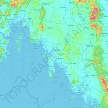
Name: Krabi Province topographic map, elevation, terrain.
Location: Krabi Province, Thailand (7.07608 98.59964 8.68184 99.41499)
Average elevation: 69 m
Minimum elevation: -3 m
Maximum elevation: 1,695 m
Other topographic maps
Click on a map to view its topography, its elevation and its terrain.
Prachuap Khiri Khan
Thailand > Mueang Prachuap Khiri Khan
Prachuap Khiri Khan covers an area totaling 6,367 square kilometers (2,458 sq mi). The province is on the Kra Isthmus, the narrow land bridge connecting the Malay Peninsula with mainland Asia. The province has one of the narrowest parts of Thailand, just 12.38 km (7.69 mi) from the Gulf of Thailand to the…
Average elevation: 9 m
Ban Bang Sao Thong
Thailand > Bang Sao Thong Subdistrict Administrative Organization > Bang Sao Thong Subdistrict
Average elevation: 4 m
Phu Kradung
Phu Kradueng National Park (Thai: อุทยานแห่งชาติภูกระดึง), in the Si Than sub-district of Amphoe Phu Kradueng, Loei Province, is a national park in Thailand. It has a high point of 1,316 m (4318 ft) elevation at Khok Moei. It was proclaimed a national park on 23…
Average elevation: 1,183 m
Ban Khlong Lat Krabang
Thailand > Racha Thewa Subdistrict Administrative Organization > Racha Thewa Subdistrict
Average elevation: 4 m