
Thank you for supporting this site ❤️
Make a donation
Make a donation
Viger topographic map
Click on the map to display elevation.
Thank you for supporting this site ❤️
Make a donation
Make a donation
About this map
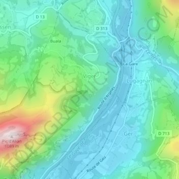
Name: Viger topographic map, elevation, terrain.
Average elevation: 543 m
Minimum elevation: 384 m
Maximum elevation: 1,070 m
Thank you for supporting this site ❤️
Make a donation
Make a donation
Other topographic maps
Click on a map to view its topography, its elevation and its terrain.
Pic du Midi de Bigorre
France > Occitania > Hautes Pyrenees > Bagnères-de-Bigorre
Average elevation: 2,280 m
Eget Village
France > Occitania > Hautes Pyrenees > Aragnouet > Eget Village
Average elevation: 1,560 m