
Escoural topographic map
Interactive map
Click on the map to display elevation.
About this map
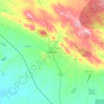
Name: Escoural topographic map, elevation, terrain.
Average elevation: 269 m
Minimum elevation: 163 m
Maximum elevation: 430 m
Other topographic maps
Click on a map to view its topography, its elevation and its terrain.
São Brissos
Portugal > Évora > Santiago do Escoural
São Brissos, Santiago do Escoural, Montemor-o-Novo, Évora, 7050-555, Portugal
Average elevation: 255 m