
Thank you for supporting this site ❤️
Make a donation
Make a donation
Union topographic map
Click on the map to display elevation.
Thank you for supporting this site ❤️
Make a donation
Make a donation
About this map
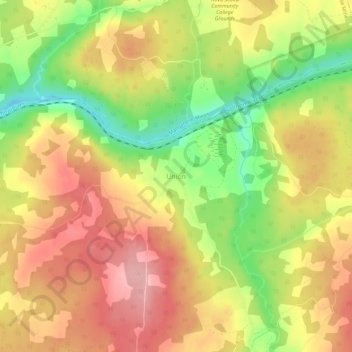
Name: Union topographic map, elevation, terrain.
Average elevation: 124 m
Minimum elevation: 42 m
Maximum elevation: 188 m
Thank you for supporting this site ❤️
Make a donation
Make a donation
Other topographic maps
Click on a map to view its topography, its elevation and its terrain.
Princton Heights Park
Canada > Nova Scotia > Municipality of Colchester > Salmon River
Average elevation: 59 m
Thank you for supporting this site ❤️
Make a donation
Make a donation
Thank you for supporting this site ❤️
Make a donation
Make a donation
Onslow Mountain
Canada > Nova Scotia > Municipality of Colchester > Onslow Mountain
Average elevation: 115 m
Thank you for supporting this site ❤️
Make a donation
Make a donation
Shubenacadie East
Canada > Nova Scotia > Municipality of Colchester > Shubenacadie East
Average elevation: 28 m
Thank you for supporting this site ❤️
Make a donation
Make a donation