
Schalbruch topographic map
Interactive map
Click on the map to display elevation.
Schalbruch
Schalbruch ligt op een hoogte van ongeveer 38 meter. Ten noorden van Schalbruch ligt de steilrand naar het hoogterras van de Maas, met een bosgebied aansluitend aan het Nederlandse natuurgebied Het Haeselaar, Bos en Broek en De Kuyper. Naar het westen toe is er -deels ontgonnen moerasland (Hohbruch).
About this map
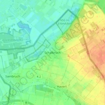
Name: Schalbruch topographic map, elevation, terrain.
Average elevation: 42 m
Minimum elevation: 27 m
Maximum elevation: 62 m