
Loch Leven topographic map
Interactive map
Click on the map to display elevation.
About this map
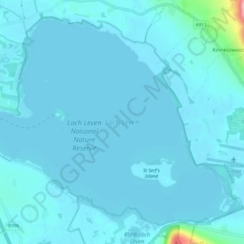
Name: Loch Leven topographic map, elevation, terrain.
Average elevation: 114 m
Minimum elevation: 105 m
Maximum elevation: 279 m
Other topographic maps
Click on a map to view its topography, its elevation and its terrain.
Loch Leven National Nature Reserve
United Kingdom > Scotland > Perth and Kinross > Kinross
Loch Leven National Nature Reserve, Kinross, Perth and Kinross, Scotland, KY13 9LX, United Kingdom
Average elevation: 119 m