
Make a donation
Heiningen topographic map
Click on the map to display elevation.
Make a donation
About this map
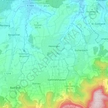
Name: Heiningen topographic map, elevation, terrain.
Average elevation: 425 m
Minimum elevation: 332 m
Maximum elevation: 776 m
Make a donation
Other topographic maps
Click on a map to view its topography, its elevation and its terrain.
Aichelberg
Deutschland > Baden-Württemberg > Landkreis Göppingen > Aichelberg > Aichelberg
Die Gemeinde Aichelberg liegt zwischen Stuttgart und Ulm und in Luftlinie etwa zehn Kilometer südwestlich der Kreisstadt Göppingen am Albtrauf, dem Nordwestabhang der Schwäbischen Alb, in einer Höhe von 357 bis 615 m ü. NHN. Das langgestreckte Gebiet der Gemeinde zieht sich von etwas unterhalb des…
Average elevation: 431 m
Zwerenberg
Deutschland > Baden-Württemberg > Landkreis Göppingen > Lauterstein
Average elevation: 717 m
Hohenstaufen
Deutschland > Baden-Württemberg > Landkreis Göppingen > Göppingen
Average elevation: 473 m
Make a donation
Hattenhofen
Deutschland > Baden-Württemberg > Landkreis Göppingen > Hattenhofen > Hattenhofen
Average elevation: 377 m
Eybach
Deutschland > Baden-Württemberg > Landkreis Göppingen > Geislingen an der Steige > Eybach
Average elevation: 619 m
Unterdrackenstein
Deutschland > Baden-Württemberg > Landkreis Göppingen > Drackenstein
Average elevation: 734 m
Make a donation
Türkheim
Deutschland > Baden-Württemberg > Landkreis Göppingen > Geislingen an der Steige
Average elevation: 645 m
Make a donation
Schopflenberg
Deutschland > Baden-Württemberg > Landkreis Göppingen > Göppingen
Average elevation: 370 m
Make a donation
Bünzwangen
Deutschland > Baden-Württemberg > Landkreis Göppingen > Ebersbach an der Fils
Average elevation: 341 m
Hofstett am Steig
Deutschland > Baden-Württemberg > Landkreis Göppingen > Geislingen an der Steige > Weiler ob Helfenstein
Average elevation: 612 m
Eselhöfe
Deutschland > Baden-Württemberg > Landkreis Göppingen > Mühlhausen im Täle
Average elevation: 710 m
Make a donation
Make a donation
Krummwälden
Deutschland > Baden-Württemberg > Landkreis Göppingen > Eislingen/Fils
Average elevation: 392 m
Lützelalb
Deutschland > Baden-Württemberg > Landkreis Göppingen > Weißenstein
Average elevation: 661 m
Make a donation
Schinder
Deutschland > Baden-Württemberg > Landkreis Göppingen > Rechberghausen
Average elevation: 365 m
Weiler ob Helfenstein
Deutschland > Baden-Württemberg > Landkreis Göppingen > Geislingen an der Steige
Average elevation: 601 m
Make a donation
Eschenbäche
Deutschland > Baden-Württemberg > Landkreis Göppingen > Eislingen/Fils
Average elevation: 415 m
Autal
Deutschland > Baden-Württemberg > Landkreis Göppingen > Bad Überkingen
Schutzzweck ist die Erhaltung einer hervorragend ausgebildeten Schluchtwaldgesellschaft an den nördlich exponierten Talhängen des Autales. Zur Albhochfläche hin wird das Gebiet durch einen Felskranz mit bis zu 25 m Höhe begrenzt, welcher artenreiche Moosvorkommen aufweist. Man findet dort zahlreiche…
Average elevation: 650 m
Hohenstaufen
Deutschland > Baden-Württemberg > Landkreis Göppingen > Göppingen
Average elevation: 473 m
Make a donation