
Thank you for supporting this site ❤️
Make a donation
Make a donation
Sunray topographic map
Click on the map to display elevation.
Thank you for supporting this site ❤️
Make a donation
Make a donation
About this map
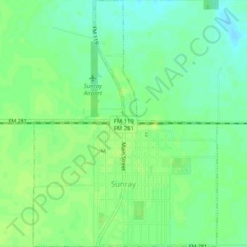
Name: Sunray topographic map, elevation, terrain.
Location: Sunray, Moore County, Texas, 79086, United States (36.00930 -101.83775 36.03832 -101.81093)
Average elevation: 1,067 m
Minimum elevation: 1,059 m
Maximum elevation: 1,073 m
Thank you for supporting this site ❤️
Make a donation
Make a donation
Other topographic maps
Click on a map to view its topography, its elevation and its terrain.