
Pohnpei topographic map
Interactive map
Click on the map to display elevation.
About this map
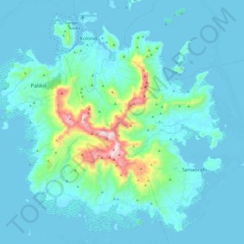
Name: Pohnpei topographic map, elevation, terrain.
Average elevation: 87 m
Minimum elevation: -1 m
Maximum elevation: 782 m
Other topographic maps
Click on a map to view its topography, its elevation and its terrain.
Dolen Kahk
Federated States of Micronesia > Pohnpei > Nett
Dolen Kahk, Nett, Peidie kousapw, Pohnpei, Federated States of Micronesia
Average elevation: 265 m
Pohnpei
Federated States of Micronesia > Pohnpei
Pohnpei, Federated States of Micronesia
Average elevation: 0 m