
Ballard County topographic map
Interactive map
Click on the map to display elevation.
About this map
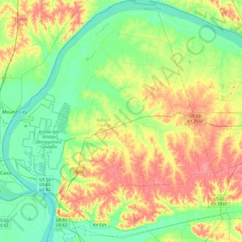
Name: Ballard County topographic map, elevation, terrain.
Location: Ballard County, Kentucky, Estados Unidos da América (36.91546 -89.18251 37.22989 -88.81583)
Average elevation: 113 m
Minimum elevation: 87 m
Maximum elevation: 153 m
Other topographic maps
Click on a map to view its topography, its elevation and its terrain.
Nelson County
Estados Unidos da América > Kentucky
Nelson County, Kentucky, Estados Unidos da América
Average elevation: 207 m
Covington
Estados Unidos da América > Kentucky > Covington
Covington, Condado de Kenton, Kentucky, Estados Unidos da América
Average elevation: 215 m
Westwood
Estados Unidos da América > Kentucky > Westwood
Westwood, Jefferson County, Kentucky, Estados Unidos da América
Average elevation: 196 m
New Haven
Estados Unidos da América > Kentucky > New Haven
New Haven, Nelson County, Kentucky, Estados Unidos da América
Average elevation: 153 m
Georgetown
Estados Unidos da América > Kentucky > Georgetown
Georgetown, Scott County, Kentucky, 40324, Estados Unidos da América
Average elevation: 265 m
Middlesborough
Estados Unidos da América > Kentucky > Middlesborough
Middlesborough, Bell County, Kentucky, Estados Unidos da América
Average elevation: 406 m