
Thank you for supporting this site ❤️
Make a donation
Make a donation
La Loge topographic map
Click on the map to display elevation.
Thank you for supporting this site ❤️
Make a donation
Make a donation
About this map
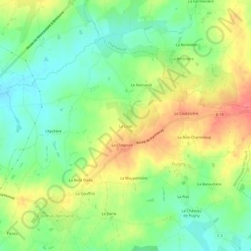
Name: La Loge topographic map, elevation, terrain.
Average elevation: 193 m
Minimum elevation: 164 m
Maximum elevation: 230 m
Thank you for supporting this site ❤️
Make a donation
Make a donation
Other topographic maps
Click on a map to view its topography, its elevation and its terrain.
Saint-Jouin-de-Milly
France > Nouvelle-Aquitaine > Deux-Sèvres > Moncoutant-sur-Sèvre
Average elevation: 167 m
Thank you for supporting this site ❤️
Make a donation
Make a donation