Yayla Patlangıç topographic map
Interactive map
Click on the map to display elevation.
About this map
![Yayla Patlangıç topographic map, elevation, terrain](/pub/maps/node/p7rr/nr2jjhcz/thumbnail.jpg)
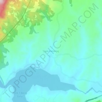
Name: Yayla Patlangıç topographic map, elevation, terrain.
Location: Yayla Patlangıç, Seydikemer, Muğla, Aegean Region, Turkey (36.82270 29.51190 36.86270 29.55190)
Average elevation: 1,172 m
Minimum elevation: 1,104 m
Maximum elevation: 1,455 m
Other topographic maps
Click on a map to view its topography, its elevation and its terrain.
![Yayla Gökben topographic map, elevation, terrain](/pub/maps/node/dvz4/v6ftjqt6/icon.jpg)
Yayla Gökben
Yayla Gökben, Seydikemer, Muğla, Aegean Region, Turkey
Average elevation: 1,390 m