
Make a donation
Hemer topographic map
Click on the map to display elevation.
Make a donation
Hemer
Hemer is located at the north end of the Sauerland near the Ruhr river. The highest elevation, at 546 metres (1,791 feet), is in the Balver Wald in the south of the city. The lowest elevation, at 160 metres (520 feet), is at the Edelburg in the northeast.
Make a donation
About this map
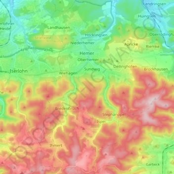
Name: Hemer topographic map, elevation, terrain.
Location: Hemer, Märkischer Kreis, North Rhine-Westphalia, 58675, Germany (51.31223 7.72022 51.41748 7.85342)
Average elevation: 326 m
Minimum elevation: 151 m
Maximum elevation: 547 m
Make a donation
Other topographic maps
Click on a map to view its topography, its elevation and its terrain.
Ebbegebirge
Germany > North Rhine-Westphalia > Märkischer Kreis > Herscheid
The highest elevation in the Ebbe Mountains is the Nordhelle (663.3 m above NN) between Valbert and Herscheid. Other notable hills are the: Rehberg (645.9 m), Rüenhardt (636.0 m), Waldberg (ca. 635 m), Rothenstein (ca. 600 m), Der Griesing (552,6 m), Homert (538,3 m) and Kahler Kopf (540.1 m).
Average elevation: 550 m