
Make a donation
Sterling topographic map
Click on the map to display elevation.
Make a donation
Sterling
According to the USGS, Sterling has an average elevation of 289 feet (88 m) above sea level. The original center of Sterling is located at 39°00'22.4"N 77°25'43.0"W. Sterling is part of the Chesapeake Bay watershed, and Greater Sterling borders the Potomac River.
Make a donation
About this map
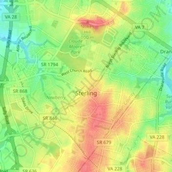
Name: Sterling topographic map, elevation, terrain.
Location: Sterling, Loudoun County, Virginia, 20164, United States (38.98265 -77.43529 39.02500 -77.37108)
Average elevation: 97 m
Minimum elevation: 66 m
Maximum elevation: 131 m
Make a donation
Other topographic maps
Click on a map to view its topography, its elevation and its terrain.
Loudoun Valley Estates
United States > Virginia > Loudoun County
The land around Loudoun Valley Estates is gently rolling. The average elevation is 289 feet (88 m). The population density is about 500 people per square kilometer.
Average elevation: 91 m
Make a donation
Make a donation
Make a donation