
Make a donation
Pickens County topographic map
Click on the map to display elevation.
Make a donation
Pickens County
According to the U.S. Census Bureau, the county has a total area of 512.75 square miles (1,328.0 km2), of which 496.94 square miles (1,287.1 km2) is land and 15.81 square miles (40.9 km2) (3.67%) is water. The county also contains the highest natural point in South Carolina, Sassafras Mountain, with an elevation of 3,560 feet (1,090 m). Table Rock State Park is in Pickens County.
Make a donation
About this map
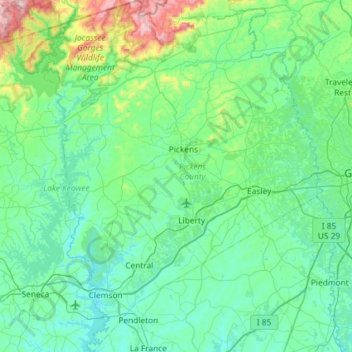
Name: Pickens County topographic map, elevation, terrain.
Location: Pickens County, South Carolina, United States (34.60730 -82.94366 35.08594 -82.47646)
Average elevation: 326 m
Minimum elevation: 188 m
Maximum elevation: 1,115 m
Make a donation
Other topographic maps
Click on a map to view its topography, its elevation and its terrain.
Make a donation
Florence
United States > South Carolina > Florence County > Florence
Florence is located in the coastal plain of South Carolina. It is in the northeastern part of the state and the northern part of Florence County. The average elevation above sea level is around 140 ft (43 m). Jeffries Creek is a tributary of the Great Pee Dee River and is the main waterway that flows through…
Average elevation: 35 m
Garden City Beach
United States > South Carolina > Horry County > Garden City Beach
Average elevation: 4 m