
Thank you for supporting this site ❤️
Make a donation
Make a donation
York County topographic map
Click on the map to display elevation.
Thank you for supporting this site ❤️
Make a donation
Make a donation
About this map
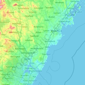
Name: York County topographic map, elevation, terrain.
Location: York County, Maine, United States (42.92222 -70.98912 43.81428 -70.22209)
Average elevation: 72 m
Minimum elevation: -6 m
Maximum elevation: 757 m
Thank you for supporting this site ❤️
Make a donation
Make a donation