
Leipzig topographic map
Interactive map
Click on the map to display elevation.
About this map
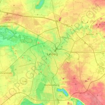
Name: Leipzig topographic map, elevation, terrain.
Location: Leipzig, Saxony, Germany (51.23817 12.23665 51.44811 12.54254)
Average elevation: 126 m
Minimum elevation: 82 m
Maximum elevation: 177 m
Other topographic maps
Click on a map to view its topography, its elevation and its terrain.
Freital
Germany > Saxony > Sächsische Schweiz-Osterzgebirge
Freital, Sächsische Schweiz-Osterzgebirge, Saxony, 01705, Germany
Average elevation: 275 m
Erdmannsdorf
Germany > Saxony > Mittelsachsen > Augustusburg
Erdmannsdorf, Augustusburg, Mittelsachsen, Saxony, 09573, Germany
Average elevation: 376 m
Mandau/Mandava
Mandau/Mandava, Görlitz, Saxony, 02782, Germany
Average elevation: 415 m
Fichtelberg
Germany > Saxony > Oberwiesenthal
Fichtelberg, Oberwiesenthal, Erzgebirgskreis, Saxony, 09484, Germany
Average elevation: 1,038 m