
Amona topographic map
Interactive map
Click on the map to display elevation.
About this map
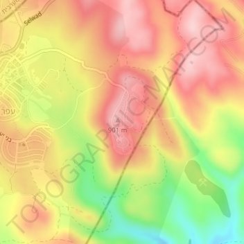
Name: Amona topographic map, elevation, terrain.
Location: Amona, Area C, Judea and Samaria, Palestinian Territories (31.94885 35.27405 31.95583 35.27809)
Average elevation: 823 m
Minimum elevation: 695 m
Maximum elevation: 908 m
Other topographic maps
Click on a map to view its topography, its elevation and its terrain.
Dead Sea
Palestinian Territories > Judea and Samaria > Area C
The lake's surface is 430.5 metres (1,412 ft) below sea level, making its shores the lowest land-based elevation on Earth. It is 304 m (997 ft) deep, the deepest hypersaline lake in the world. With a salinity of 342 g/kg, or 34.2% (in 2011), it is one of the world's saltiest bodies of water – 9.6 times as…
Average elevation: 105 m