
Lagos topographic map
Interactive map
Click on the map to display elevation.
About this map
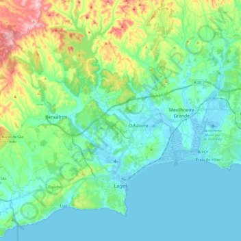
Name: Lagos topographic map, elevation, terrain.
Location: Lagos, Faro, Algarve, Portugal (37.07123 -8.85321 37.23502 -8.61915)
Average elevation: 77 m
Minimum elevation: -1 m
Maximum elevation: 255 m
Other topographic maps
Click on a map to view its topography, its elevation and its terrain.
São Brás de Alportel
Portugal > Algarve > São Brás de Alportel
São Brás de Alportel, Faro, Algarve, Portugal
Average elevation: 322 m
Praia da Luz
Portugal > Algarve > Luz > Espiche
Praia da Luz, Rua da Praia, Espiche, Luz, Lagos, Faro, Algarve, 8600-160, Portugal
Average elevation: 35 m