
Make a donation
Dundalk topographic map
Click on the map to display elevation.
Make a donation
Dundalk
Most of Dundalk is flat and very near sea level, with a few small hills close to the city of Baltimore to the west. Dundalk is part of the Atlantic Coastal Plain. Elevations range from sea level on the shore of the Chesapeake Bay to approximately 40 feet (12 m) above sea level along the northern reaches of Dundalk Avenue and North Point Boulevard.
Make a donation
About this map
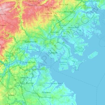
Name: Dundalk topographic map, elevation, terrain.
Location: Dundalk, Baltimore County, Maryland, 21222, United States (39.09741 -76.68367 39.41741 -76.36367)
Average elevation: 33 m
Minimum elevation: -3 m
Maximum elevation: 173 m
Make a donation
Other topographic maps
Click on a map to view its topography, its elevation and its terrain.
Make a donation
Turkey Point Park
United States > Maryland > Baltimore County > Dundalk > Turkey Point
Average elevation: 2 m
Make a donation
Make a donation
Make a donation