
Riveris topographic map
Interactive map
Click on the map to display elevation.
About this map
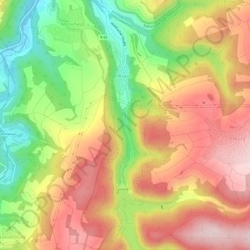
Name: Riveris topographic map, elevation, terrain.
Average elevation: 348 m
Minimum elevation: 169 m
Maximum elevation: 501 m
Other topographic maps
Click on a map to view its topography, its elevation and its terrain.
Muhl
Deutschland > Rheinland-Pfalz > Landkreis Trier-Saarburg > Neuhütten
Muhl, Neuhütten, Hermeskeil, Landkreis Trier-Saarburg, Rheinland-Pfalz, 54422, Deutschland
Average elevation: 638 m
Schöndorf
Deutschland > Rheinland-Pfalz > Landkreis Trier-Saarburg > Schöndorf
Schöndorf, Ruwer, Landkreis Trier-Saarburg, Rheinland-Pfalz, Deutschland
Average elevation: 390 m
Riol
Deutschland > Rheinland-Pfalz > Landkreis Trier-Saarburg > Riol
Riol, Schweich an der Römischen Weinstraße, Landkreis Trier-Saarburg, Rheinland-Pfalz, Deutschland
Average elevation: 226 m