
硫黄鳥島 topographic map
Interactive map
Click on the map to display elevation.
About this map
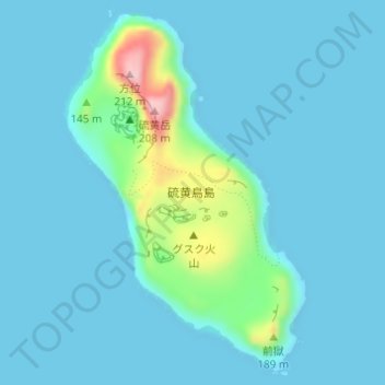
Name: 硫黄鳥島 topographic map, elevation, terrain.
Location: 硫黄鳥島, 久米島町, 島尻郡, Präfektur Okinawa, Region Kyūshū, Japan (27.86033 128.21750 27.88544 128.23644)
Average elevation: 25 m
Minimum elevation: -1 m
Maximum elevation: 211 m