
Rapperswil topographic map
Interactive map
Click on the map to display elevation.
About this map
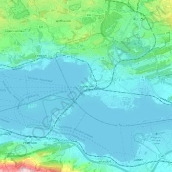
Name: Rapperswil topographic map, elevation, terrain.
Average elevation: 448 m
Minimum elevation: 402 m
Maximum elevation: 723 m
Other topographic maps
Click on a map to view its topography, its elevation and its terrain.
Wagen
Schweiz > St. Gallen > Wahlkreis See-Gaster > Rapperswil-Jona
Wagen, Rapperswil-Jona, Wahlkreis See-Gaster, St. Gallen, 8646, Schweiz
Average elevation: 458 m
Jona
Schweiz > St. Gallen > Wahlkreis See-Gaster > Rapperswil-Jona
Jona, Rapperswil-Jona, Wahlkreis See-Gaster, St. Gallen, 8645, Schweiz
Average elevation: 453 m