
Town of Amherst topographic map
Interactive map
Click on the map to display elevation.
About this map
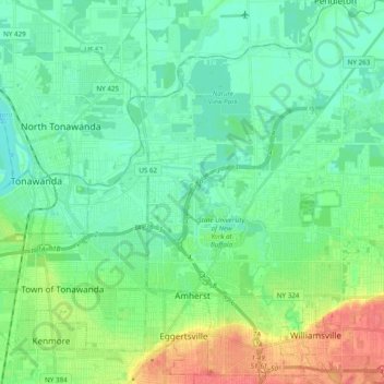
Name: Town of Amherst topographic map, elevation, terrain.
Location: Town of Amherst, Erie County, New York, United States (42.94584 -78.83250 43.08708 -78.69684)
Average elevation: 184 m
Minimum elevation: 169 m
Maximum elevation: 220 m
Other topographic maps
Click on a map to view its topography, its elevation and its terrain.
Town of Orchard Park
United States > New York > Erie County
Town of Orchard Park, Erie County, New York, 14127, United States
Average elevation: 272 m
Getzville
United States > New York > Erie County > Town of Amherst
Getzville, Town of Amherst, Erie County, New York, 14068, United States
Average elevation: 179 m
Onondaga Escarpment
United States > New York > Erie County > Village of Akron
Onondaga Escarpment, Village of Akron, Town of Newstead, Erie County, New York, 14001, United States
Average elevation: 235 m
Town of Cheektowaga
United States > New York > Erie County
Town of Cheektowaga, Erie County, New York, United States
Average elevation: 201 m
Town of Colden
United States > New York > Erie County
Town of Colden, Erie County, New York, 14033, United States
Average elevation: 412 m
Sandy Beach
United States > New York > Erie County > Town of Grand Island
Sandy Beach, Town of Grand Island, Erie County, New York, 14304, United States
Average elevation: 175 m
East Aurora
United States > New York > Erie County
East Aurora, Town of Aurora, Erie County, New York, 14052, United States
Average elevation: 283 m
Tonawanda
United States > New York > Erie County > Tonawanda
Tonawanda, Erie County, New York, United States
Average elevation: 180 m
Buffalo
United States > New York > Erie County
Buffalo, Erie County, New York, United States
Average elevation: 185 m
Village of Orchard Park
United States > New York > Erie County > Town of Orchard Park
Village of Orchard Park, Town of Orchard Park, Aurora, Erie County, New York, 14127, United States
Average elevation: 262 m